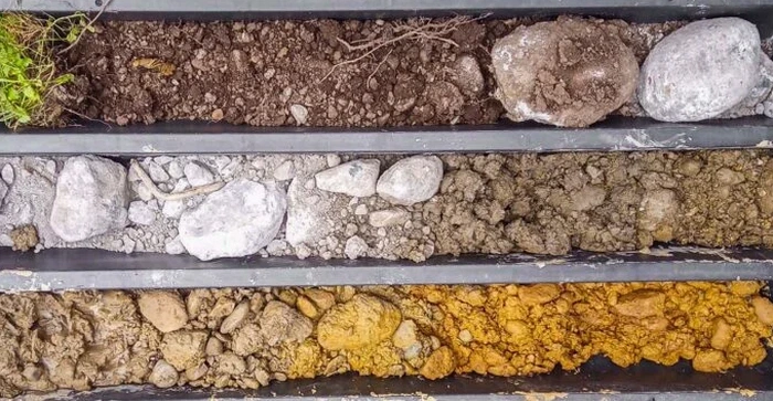
AS 1726:2017 sets the national benchmark for geotechnical site investigations, and in Toowoomba, adhering to its guidelines for direct observation methods is not just a contractual obligation—it is the most reliable way to de-risk a project on the region's complex residual basalt profiles. The Darling Downs' volcanic origins have left a legacy of highly variable ground, where competent rock can transition into expansive clay or completely weathered material within a few metres. An exploratory test pit, excavated to expose the in-situ soil and rock strata, allows our engineers to map these transitions visually, collect undisturbed block samples, and conduct immediate pocket penetrometer assessments. For projects extending across the Toowoomba Range escarpment, where colluvium and ancient landslide debris are common, this direct visual logging is fundamental to validating borehole data and understanding true ground conditions before a single footing is poured.
Direct observation through a properly logged test pit remains the only field method that lets you see the soil fabric, moisture condition, and discontinuity spacing with your own eyes before committing to a foundation design.
Area-specific notes
A mistake we see too often in Toowoomba is treating the brown-black cracking clay found across the eastern suburbs as a uniform, moderately reactive layer without confirming its profile depth with a test pit. The Red Ferrosol and Black Vertosol boundary can undulate sharply, and assuming a consistent depth of reactive material—say 1.2 metres—when the pit would have revealed a 2.4-metre deep pocket of highly expansive clay under a corner of the slab leads to differential movement, cracked masonry, and a five-figure remedial underpinning bill that no warranty will fully cover. The exploratory test pit cuts through this assumption in an afternoon, exposing the true clay thickness and letting the structural engineer specify the correct beam depth and reinforcement. When you consider that Toowoomba's average annual rainfall of 944 mm drives seasonal moisture cycles deep into these soils, skipping this investigation is gambling with a mechanism that is already well understood and entirely manageable.
FAQ
What is the typical cost of an exploratory test pit in Toowoomba for a standard residential block?
For a single exploratory test pit on a standard residential block in Toowoomba, the cost typically falls between $770 and $1,130. The final figure depends on machine access, the required depth—usually up to 3 metres for a site classification—and whether the pit is backfilled with the excavated material or requires imported engineered fill.
How do you manage safety when excavating a test pit deeper than 1.5 metres in Toowoomba's clay soils?
Any pit exceeding 1.5 metres is treated as a confined space under our safety protocol, with mandatory battering of the walls to a safe angle or the installation of a trench shield. Toowoomba's Black Vertosol clays can stand vertically when dry but collapse without warning after rain, so we continuously monitor soil moisture and adjust the batter slope accordingly, and a spotter remains at the surface throughout the logging operation.
Can you use a test pit instead of a borehole to determine the founding depth for a retaining wall on a sloping Toowoomba block?
In many slope scenarios, a test pit is actually superior to a borehole because it exposes the true dip and spacing of defects in the weathered basalt, which a core barrel can miss. We log the face of the pit to map the rockhead profile and any clay seams, and combine that with a DCP test at the base of the pit to confirm the allowable bearing pressure for the retaining wall footing.
How do you restore the site after completing an exploratory test pit?
The excavated material is returned in reverse order as closely as practical, with each lift compacted using a hand-operated plate compactor to minimise future settlement. In landscaped areas, we separate and stockpile the topsoil before digging and replace it last, leaving the surface graded to match the surrounding ground. A completion report photographs the reinstated area and notes the compaction method used.